Walking in Monmouthshire
 Abergavenny
Abergavenny with 3 mountain peaks in the vicinity is the perfect hub for exploring the expansive Brecon Beacons. The three main peaks The Sugarloaf, the Skirrid and Pen-y-fan also have car parks closer to the summits for those who prefer a shorter climb.
The Sugarloaf (the highest of the three peaks) provides spectacular views across unspoiled parts of the local countryside, whilst the Blorenge offers dizzying views over the town of Abergavenny itself. The Skirrid has a steep initial climb, which then breaks out onto a long ridgeway which ends by the ruins of an old chapel at the highest point.
For the hardened walker, the historic Offa's Dyke footpath runs nearby. Built by Offa, King of Mercia in 757 to 796 AD the dyke formed the boundary between England & Wales, running 182 miles from Prestatyn in the north to Sedbury, near Chepstow in the south.
Pen-Y-Fan, the highest mountain in South Wales, and the 20th highest peak in Wales.
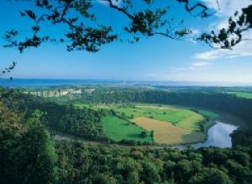
Chepstow
The Wye Valley & Vale of Usk contains around 1,500 miles of public rights of way.
The nearest walks pass through the Farm. With many more including the Wye Valley Walk, Usk Valley Walk, Brecon and Monmouthshire canal and the famous Offa’s Dyke Path that runs along the Welsh-English border.
In its 177 miles / 285 kilometres it passes through no less than eight different counties and crosses the border between England and Wales over 20 times